Hiking Photos

Saturday, December 17, 2011

FAMILY MATTERS

20TH HIKE: PILOT MOUNTAIN

Facts

Location: Pinnacle, NC

Park: Pilot Mountain State Park

Trail: Summit Trail - 3.5 mi

Elevation: 2,421 ft

Date: 12/11/11

Adventure

And so the journey begins with a jet pack finish to fall semester 2011! Friday was a fourteen hour day of work, volunteering, and celebrating! Saturday I had my final statistics course in which we did a practice comprehensive exam followed by a presentation of my dissertation research proposal. From 9am-11am I was a student, after that an adventure seeking vagabond! Adrenaline was pumping through my veins as my foot hit the pedal and cleared way on the open road to North Carolina. My mother in her most loving way told me, "Ashley you are the craziest person I know."

The knob
I arrived in Madison, NC...aka the "big city" to visit my cousin Andrew for the weekend. I had asked Andrew if we could go hiking on my trip and he said he knew just the place. I was happy to take a back seat on planning and just enjoy the ride for my final showdown. We drove to Pilot mountain laughing and jamming out to Reggae. We ascended to the top of the mountain where Andrew informed me that we could not hike from bottom to top, but rather up, down, and around the knob at the apex. It was a bright and sunny day with low temperatures. Andrew and I began in several layers. I had a tank, thermal, flannel, sweatshirt, leggings, and sweat pants. I was expecting the worst being on top of the mountain, but not even a mile into our trek I ended up removing the sweatshirt and sweating in the flannel. Andrew was able to walk around in a T-shirt comfortably as we circled around the mountain top. Stopping to take views from the pinnacle of the land surrounding us.

We sent this photo to mom just to piss her off!
On the hike Andrew and I used the time to catch up on each other's life. As kids we were close, but by the time we were teenagers the distance between North Carolina and Massachusetts took its toll. A decade has passed before Andrew's family and mine were reunited during a magical Christmas Eve filled with drinking, laughter, and of course a Little Mermaid sing-a-long. After that Christmas Eve, Andrew and I stayed in touch through email and phone conversations and were determined to hang out again soon, we recognized many distinct similarities between us, starting with our passion for working with the "old folk" and exploring the great outdoors. We mostly told stories about "Auntie Micky" or to many of you reading this blog, GRAM! Andrew was kind and reminded me how fortunate I am to have my grandparents around, to recount our family history and continue to build memories with them. Once we got passed conversation about Gram shrinking we moved on to our favorite topic, making fun of our mother's. We spent most of the weekend discussing silly things that our mom's say to us, for example if I were to not call my mother at least once a week she would call me and say "Ash are you alive?" and I would respond, "Yeah. I picked up the phone didn't I?" We could have gone on for weeks sharing momism.


This is why I hike!
The hike was gorgeous! The views incredible! We stood on the edge and looked straight down from the cliff. We saw hawks soaring. There was still green on some of the trees. We stopped to reach our hands out and catch running water. Nature was magical and in rare form as always and intended. The incredible part of the adventure was being with my cousin and growing up with him. I value storytelling and I was happy to be carve out time in my life, to not be spread so thin and just enjoy the company of my family. A part of my family that I do not get to see everyday. I do not take that lightly and feel truly blessed to have been afforded the experience to bond!


the edge

Tuesday, December 13, 2011

MAYBE WE SHOULD TURN AROUND?

19TH HIKE: WALKABOUT TRAIL

Facts

Location: Pascoag, RI

Park: George Washington Park

Trail:  Walkabout - 8 miles (we ended up walking 10-12 miles, we got lost!)

Date: 10/8/11

The Adventure

I was home for my grandparents 60th anniversary celebration up in Northampton, MA. That Saturday while back in Worcester I decided to find a local hike that I had yet to go on and naturally fell short of spots in Massachusetts. I had completed a limited amount of hiking in Rhode Island and through some research landed on walkabout. Erika and Eric decided to join me for the occasion and I selected the walkabout trail because it was close by, it had different trail options, and most importantly I loved the name. I would not so secretly love to go on a legit walkabout, as in a "spiritual journey" like the Aboriginal Australians did, at some point in my life. I was mostly excited for my first and only chance to spot the foliage in New England this year!


I was leaving for Philly that evening after the hike so Eric, Erika, and I decided that the 6 mile trail would be best because the 2 mi would be short and the 8 mi trail would be cutting it close to dinner time back at the Banner. The trail was really beautiful, full of hills, and obstacles through the woods. Erika and I spent most of the time catching up on our lives, discussing jobs, the future, and education. When the trail forked we went left deciding that there should be an end to the six mile trail soon. When we came out to the dirt road we determined that it must have been the six mile stop point and thought we should just walk down main path back to the car. It was getting late and we were all hungry.


We started going in one direction only to realize we were not quite sure if we were walking towards the car. We asked for directions and realized we were going the wrong way, thus turning around again. The people giving us directions were not entirely sure so I used my iphone to determine we should turn around for the third time. After walking for 1-2 miles and realizing that we were not getting any closer I consulted the phone one last time. It demonstrated that we were still another 2 miles from the car going in the wrong direction. I was waiting for Eric or Erika to beat me up for all the blunders I had made in trying to guide us back to the car. We finally got back to the road we drove in on and we're so grateful! A park ranger drove by and asked if we were lost and if we wanted a ride. Eric and I looked at each other and hesitated a moment given our high level of pride before finally submitting and taking the ride back (which saved us an additional ten minutes of walking.) It was a long day on the trail and despite the unnecessary walk back to the car I truly enjoyed it! Also even though I was slightly late I still made it to the Banner for dinner before the lengthy drive home.
Please don't kill me!

Tuesday, October 18, 2011

THE SPIRIT OF TUSCARORA

18TH HIKE: THE SPIRIT OF TUSCARORA

Facts

Location: Blain, PA

Park: Tuscarora State Forest

Trail:  The Spirit of Tuscarora - 4.5 miles

Date: 9/17/11


SHADES OF DEATH

 17TH HIKE: SHADES OF DEATH

Facts

Location:  near White Haven, PA

Park: Hickory Run State Park

Trail:  Shades of Death - 1.5 miles

Date: 9/10/11


RUN KELLY RUN!

16TH HIKE: KELLY'S RUN

Facts

Location: Holtwood, PA

Park: Holtwood Recreational Area

Trail:  Kelly's Run - 4 miles

Time: 1 hour 40 minutes

Rating: Difficult - takes an experienced hiker 2.5 hours

Date: 9/2/11

Adventure

The adventure will be missing from the next four hikes. Too much time has lapsed since I completed the hikes and my brain is fried as a result of being over extended (and loving it!)

I will mention that I completed this hike with Mauricio. It was one of the BEST hikes of the summer. Incredible scenery, great cardio, plenty of laughs, ice cream & burgers as well. I love hiking in Lancaster county!


Sunday, September 25, 2011

MAGICAL (JEW)EL-VILLE

15TH HIKE: GUNPOWDER FALLS AKA "COVERED BRIDGES"

Facts

Location: Kingsville, MD

Park: Gunpowder Falls State Park

Trail: Gunpowder South Trail (?) 

Attraction: Jerusalem Mill (with re-enactments of old Jewish Quaker settlements)

Date: 8/21/11


Adventure

I took off in the Adventure-Mobile with Rebecca and Mauricio for a day of hiking in Maryland. I was excited to be hiking in a different state. When we got to gunpowder state park the mill and shops were closed until 11 or noon. At first I could not locate the trail start and went through different versions of the map trying to discern where the hike should begin. Finally I found a man in the field behind the Jerusalem Mill. My first concern was that the gentleman wouldn't break character to help guide me towards the trails, but he was kind and obliged my request (most likely because the park was not officially open yet for tourists.) Rebecca, Mauricio, and I began our jaunt down by the river...I shot my baby (sorry couldn't resist the Neil Young reference.)


Standing on the Covered Bridge
The main feature of the trail was a really cool covered bridge that we spent some time analyzing and photographing! On our walk through the woods we saw a variety of cool stones, mushrooms, bugs, and toads? The most phenomenal aspect of the hiking experience was by far the conversations that occurred. I am not sure how many miles we walked in the woods as we were on a time limit due to evening plans and rain was a factor. We constantly stopped to take photos and examine the environment around us. The experience of being out in nature and catching up with good friends was glorious, but I must be honest the hike itself was fairly simply and not too spectacular when compared to other adventures in this blog. Hiking with friends is always worth the trip and we beat out the rain on the return voyage so that was also a bonus. What was really interesting about our topic of conversation was that we spoke of  the future, energy, tarot cards, etc. There was a great deal of positive energy surrounding us on this trip to Maryland and it felt like there was magic in the air.
Orange Mushrooms
Once we completed our walk through the woods we went over to one of the actors to discuss the tools she was shaping, such as cups and combs from animal horns. Rebecca, Mauricio, and I sat around a picnic table to indulge is some treats for lunch. Rebecca had packed some chicken and I recall their being chips, granola bars, and I wanna say fruit. Just as we finished our lunch the rain arrived so we hopped in the car and headed back home for ice cream! If you've yet, to notice ice cream and food in general seem to be the themes to my tales.


Good Times!

Friday, September 23, 2011

SURPRISING LOVED ONES

14TH HIKE: MOUNT TOM

Facts

Location: Holyoke, MA

Park: Mount Tom State Reservation 

Trail:  Beau Bridges & M-M (part of it)

Elevation: 822+ ft

Date: 8/17/11

Adventure

I scooped Jully up in Auburn and drove to western Mass without telling her where we were going. I offered a vague response to every question she asked because I had secretly devised a plan to pick up David and the two of us were going to surprise Jully. After a happy reunion for the three of us we hopped in the car to grab sandwiches and hit the trail. Now I have been to Mount Tom before, but I have never hiked on the main trails with a map. I have done my own exploration in the woods and up steep parts of the mountain, so in my eyes this format of hiking this location was novel. Jully, David, and I were so hungry that we inhaled our sandwiches before the trip even took place. Oddly enough we ended up eating the wrong sandwiches as each of us failed to even look at the contents of our wraps.

Goat Peak
We hiked up the Beau Bridges trail first. David was bounding through the trail and running up the hill. The whole hike the three of us were laughing, catching up, and making inappropriate jokes about what we would do on top of goat peak. The Massachusetts greenery is truly different from PA. While both are beautiful there is something about the New England scenery that consistently takes my breath away. David, who is not easy on sincere compliments paid me a rather vibrant one, suggesting that he couldn't picture sharing nature with any one other than me. My heart was beating fondly the whole way up the hill with my loved ones, my family! Jully and I hung back on the trail and let David pass ahead as the incline was tough to tackle at some parts.

UMASS
Once we got to the top of Goat Peak we sat and looked out on the Pioneer Valley. We stopped for photo ops before climbing the lookout tower. The tower was old and rickety. The stairs were steep and the tower was high, it was quite a feat to tackle, but Jully, David, and I turned out victorious in the end. After taking in the view for a little while longer we headed back down to the car via the M-M trail, which is the largest and most beautifully, scenic trail at  Mount Tom. After coming out of the woods we were stopped by a woman and her three children seeking directions back to a specific trail on the mountain. I provided the woman with directions using my map and once through explaining I suggested she take the it so that they wouldn't get lost. We parted ways with David then Jully and I scurried home, mildly late for an enjoyable family dinner at gram's! The hike was incredible! I couldn't ask for a better day!

Top of the Tower

Monday, August 29, 2011

NO TURNING BACK NOW!

13TH HIKE: HAWK MOUNTAIN 

Facts

Location: Kempton, PA

Park: Hawk Mountain Sanctuary

Trail: Skyline (most difficult)

Elevation: 1,500+ ft

Date: 8/7/11

Adventure

New Socks!
Believe it or not I didn't pack a lunch. I anticipated hawk mountain being a short climb up, then down and back home to eat. Haha! This was one of the most amazing and exhilarating hikes of the summer! Henry and I took off for hawk mountain. I had my hiking shoes in the car and was convinced that I had wool socks in the box with them...wrong! I had to buy a pair of socks in the gift shop before hitting the trail. I asked for a map and what trail had the best views. I was told the Skyline, but that it was the most difficult trail in the park (did I hear you say difficult, just checking.) Naturally there became no other option for me. After walking arond the park with Henry checking out all the "clearview hawks" in the fog at different lookout points on the north trail, we met our match with the Skyline. There was literally no visible trail the blazes were on the rocks and we had no option, but to climb down, same idea as a cliff only not as drastic. Henry asked me one last time if I was sure that I wanted to do it, but I reckon the look in my eyes suggested there was no way I would miss out on this adventure!

Start of Skyline Trail
The climb was wild and non-stop. Once we got to a level spot on the skyline the terrain still consisted of climbing up and down rocks for almost a solid hour before reaching the connecting trails to bring us back to the visitor center. Henry and I exchanged stories about our travels, enjoyment of nature, and memories of college. We paused to indulge in some crackers and granola bars. I failed to mention that it had rained the day before and all the rocks were slippery. I totally fell several times, not cute, thank goodness for my "Katniss" like reflexes! We ended up at the river of rocks, which totally reminded me of ringing rocks, (this formation was most likely caused by an avalanche.) What was really cool about reaching the river of rocks was knowing how far away from the top we had travel, but also knowing the climb back up might be a little painful. However, no pain, no gain! We barreled our way to the top and felt quite victorious. We filled up our bottles with water by the visitors center and were on our way home, for an ice cold shower.

What should have been an two hour hike, turned into four. Still one of the better hikes I've been on this summer. I would love to go back and do it again! Also we saw walking stick bugs, and really cool shale.

Walking Sticks


Wednesday, August 24, 2011

DINO THUNDER!

12TH HIKE: DINOSAUR STATE PARK

Facts

Location: Rocky Hill, CT

Park: Dinosaur State Park

Trail: Blue, Orange, Red, & Yellow (2.2 mi)

Attraction: Dinosaur Footprints

Date: 8/4/11


Adventure

I have driven along I-91 to New York, Philly, and so on more than twenty times, in which, I constantly pass the sign that reads dinosaur state park. I was planning on hiking with Jully out in Western Mass, but she ended up at the Cape and I on my pilgrimage back to PA. I decided that today was going to be the day I stopped at this roadside attraction to check it out. I packed two pulled pork sandwiches, fruit, granola bars, and a piece of candy for the trip. It was a smooth hour and a fifteen minute drive my home in Worcester, MA. I am still convinced that the five year old in me pulled over the car...

When I arrived at the park I began roaming through the woods looking for dinosaur footprints, even though I knew damn well the must be inside the dome. I ducked off the main trail congested with small children and parents. I started running up hill and through the woods imagining that dinoaurs were alongside me. I stopped to read various signs about the geology and animals that dominated various eras. I scrunched up my arms and continued jogging around pretending to be an actual dinosaur and imagining life in a land before time (I couldn't resist.) The entire hike I contemplated entering the museum to see the footprints, but I didn't want to drop six bills and be taken for a sucka! I also knew I would never return to the park so I had to do it, I needed evidence that dinosaurs had been here.

The footprints were tiny and coated the floor of the dome. Travelers could view the footprints from 5-10 above depending on which side of the railing you were standing. In addition to being tiny footprints there was also uncertainty about the type of dino. They believed it to be an Eubrontes, but given the area of CT, palentologist claimed that they must have belonged to Dilophosaurus'. Despite the tiny prints, which I was hoping to see one giant one, I was still able to nerd out and enjoy reading all about dinosaurs! I wouldn't recommend it, but if you're really into dinosaurs it might be worth checking out.

Monday, August 22, 2011

I'LL TAKE PLEASURE AND BUSINESS

11TH HIKE: MARGINAL WAY

Facts

Location: Ogunquit, ME

Trail: Marginal Way 1.25 mi

Terrain: Rocky Seacoast

Date: 8/2/11

Adventure

On family vacation at the beach house up in Wells Maine, we decided to go to Ogunquit for an evening of shopping. As most of you know shopping isn't quite my gimmick and I had to take a conference call that evening for a group research project, so I debated making the trip at all. If my family had gone to Kennebunkport as planned I most likely would have gone back to the house, but since I knew Ogunquit is home to the Marginal Way and Perkins Cove I knew I could get lost far away from a potential retail coma. The Marginal way itself is a nice easy walk along the shore of Ogunquit beach. From the trail you can see rocks and the ocean. Not to mention at sunset the view is quite breath taking.

My mother and sister walked about half way and then my cousin and aunt walked the rest of the trip with me. During the jaunt by the sea I had to skype in for the group conference call. While walking along the gorgeous shore I was able to discuss the research project, enjoy the fresh air, and smile at the sea. The many wonders of modern technology!

If you are ever in southern Maine it's worth it to check out the marginal way, but I definitely recommend taking the walk in the evening by sunset. Even though the light won't directly shine over the water it still adds a whole new element to the journey between day and night.


Saturday, August 20, 2011

DING, DONG, DORK!

10TH HIKE: RINGING ROCKS

Facts

Location: Upper Black Eddy, PA

Park: Ringing Rocks Park

Trail: Ringing Rocks

Date: 7/27/11

Adventure

Forgive my memory, but the next few enteries may be short and sweet due to a serious account of negligance to the blog project. I have been hiking more than once a week in an effort to accomplish the goal of twenty hikes before the closing of September. The month off from hiking in June was costly, but it has been enjoyable to increase my weekly exploring.
Ringing Rocks

After researching the location of Ringing Rocks I had established two different towns, one site said Pottsgrove, another Pottstown.  Midway through the drive I realized I should probably confirm the actual address instead of just driving around. First, I called J. D. who had been to ringing rocks the day before to ask for the correct town. When she didn't pick up I called Ringing Rocks Park and learned that the location was in fact Upper Black Eddy. Colette and I stopped for sandwiches at Top of the Mall Deli, in Revere, supposedly one of the best kept secret lunch places in Bucks County (there was also an independent video store next door, which made me leap for joy.) It was delicious! We picniked before the hike. I had a chicken salad sandwich with cranberries and walnuts! Ringing Rocks is giant open space filled with bizarre rocks, potentially containing radioactive elements that produce a bell-like sound when they come in contact with a metal object. There are multiple mythologies explaining why the rocks sound like a bell when struck, but the reality is it rings!

Colette and I also walked down by the waterfalls and explored the layered rocks, that were constructed like an ampitheater. We walked down by the stream and jumped off rocks, before climbing back up the steep hill we frolicked down. After hiking for about an hour or so, knowing that Colette needed to get back early, we left. I was willing to forgo an extra hour of hiking to stop for ice cream and be home on time. We stopped at Owowcow creamery, where they made ice cream with organicly grown products. The ice cream was a little pricey, but totally worth it. I began chatting up the woman behind the register and told her we had never been before. She encouraged us to sample five or six flavors before we made our decision. Her hand was flying in and out of the ice cream buckets. I settled on a white cava strawberry flavor! Colette got lavendar! Amazing hike with cool rocks and fantastic ice cream!

Monday, July 25, 2011

BACK IN ACTION

9TH HIKE: GLEN ONOKO RUN

Facts

Location: Jim Thorpe, PA

Park: Lehigh Gorge State Park

Trail: Glen Onoko Run Falls & Lehigh Gorge Trail

Elevation: 1200 ft?

Date: 7/21/11

Adventure

As many of you know I had to take a month of from my hiking adventures due to surgery. I did not give up completely, I have been to Ridley Creek several times in the last month and even my favorite past time, Purgatory Chasm, on the fourth of July. Last Sunday (7/17/11) I participated in the Philadelphia Mud Run and that was the first day I felt like myself again, energy fully restored. In order to achieve my goal from here on out I will have to hike new locations at least twice a week. Wish me luck folks I think I can swing it!

Glen Onoko Run Falls
The plan was to hike Glen Onoko Run on Thursday with my friend Henry, but he had an interview so I decided to go it alone. After packing a PBJ, a slice spinach & tomato pizza, a fresh picked plum from Linvilla Orchards, crackers and granola bars in the cooler with extra water I drove off. I filled up my tank and grabbed a breakfast sandwich at Dunkin Donuts. I had never been to Jim Thorpe before and I have to say I love the town. It's a cute little town, which advertises adventure, history, and hiking so basically I could move there. I also got to drive by the Harry Packer Mansion where Disney got the idea for the Haunted Mansion. I drove by the Lehigh Gorge State Park entrance per usual and stopped at the Jim Thorpe River Adventures to ask for directions. I had literally missed the entrance by 20 feet; the sign was small and hidden. I decided that the hike wouldn't take long so I grabbed the pizza and a water bottle and took off. The hike up the fall was crazy steep. It was the first time I hiked something with a difficult rating on it and thought, "yeah this could be challenging." The whole trip was up the falls with rocks and landslides. It made me happy I came alone because I could go at my own pace and not worry about it being tough on others.

Time to cool off!
I must have stopped every 5 minutes to dunk my head, face, hands, legs, etc in the falls. Thankfully I did not need to pull out the inhaler, but I could feel my heart racing the whole way up. The view on top of the falls of the gorge was spectacular. I was constantly stopping to take in each vista and cool down so I didn't get heat stroke. I sat at the top eating pizza and guzzling water. I decided I wanted to walk along the gorge trail and look down at the water. I walked deep into the woods at the top and found a meadow. After 15 minutes of walking in direct sunlight with no water anywhere in sight I decided to turn around and begin my descent down the falls. At the very top of the falls it was vacant. There were no hikers anywhere to be found. Being daring and sweating profusely I decided to go bathe in the falls, but I had no swimsuit. I took off my clothes and hung them on a nearby tree and climbed into the falls in my bra & underwear. It was both exhilarating and liberating. I was so happy to immerse myself in the water and cool my whole body off. I put my clothes back on continued to walk down the trail. I met a man on my travels downhill who was a local and shared the secrets of where to hike and different vistas I could explore from the Lehigh gorge trail. I also stopped to talk to a mom and her small child who told me about how when she was younger she hiked the trail and came across a bear so she never finished. As most of you know I'm still scared if running into a bear. I have no form of protection on the trail; I think the bear might win!

Still Climbing
When I got back to the bottom of the trail I ran to the car to keep from getting Hangry. I bit into a luscious plum and let the juices drip everywhere. It was amazing! Once I cooled off in the AC I explored the town of Jim Thorpe a bit and got gas to make it home. I will definitely be going back to Jim Thrope to hike the gorge and probably Glen Onoko run again at some point. It was more difficult than Rickett's Glen and almost as fun too!

Saturday, June 18, 2011

WITHOUT CAREFUL PLANNING

8TH HIKE: TUCQUAN GLEN

Facts

Location: Holtwood/Pequea, PA

Park: Tucquan Glen Nature Preserve

Trail: Tucquan Glen Loop = 2.1 miles

Time: 1-1.5 hrs

Elevation: 235 ft

Date: 6/2/11

Adventure

Originally I had planned to hike Kelly's Run on Thursday morning, a challenging trail recommended for "experienced outdoorsmen" (Mauricio you game?), but when I reviewed the schedule for the Philadelphia Trans Health Conference (PTHC) it no longer seemed applicable. I was looking to attend the PTHC on Friday and possibly Saturday, but the workshop held by GLSEN on Safe Schools was Thursday at 4pm and Kelly's Run is a 6 mile hike. I didn't want to chance missing the conference so I switched gears and pulled an easy two mile hike out of my "back pocket" list. All I knew about Tucquan  Glen was that it had a waterfall and was a loop trail. I view trails as being challenging or scenic and so I had hoped to see something cool, but understood that it would be relatively easy. Kim suggested doing brunch that morning, but I roped her into the hike instead. I packed a cooler of water, T-fish & rel (oh, how I miss the UMASS days), some granola bars, chips and away we went to Lancaster county.

Entry to Tucquan Glen
I have lived in PA for almost two years now and have yet to spend any quality time out in Amish country, but I got small taste on the way to Tucquan Glen. As is standard now on my trailblazing quest, I got lost and needed to ask for directions. I stopped at a local park in Holtwood where a group of Amish folk were having a cookout/BBQ? and playing baseball. I asked a group of teenage boys where I could find the trail, but they had no clue. One boy went to ask his father who wasn't entirely sure and then recommended I chat with his wife, the boy's mother, who said the same things as the father about where it might be, but with more clarity. What I learned was that if I had stayed on River Road I would find Tucquan Glen campground. When I got to the campground I drove down a long, narrow, unpaved road and ask some campers where I could find the park and they told me to turn around and stay on River road. They said it would be on my left and I can't miss it, they were indeed right!


New Friends
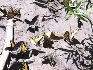
I parked the car and off we went into the woods and along the stream. The weather was gorgeous, the water was clean, and the trail made me work. After running around some to avoid the mud I had to reward my lungs with a puff or two from the old faithful inhaler. At the halfway point on the trail we crossed a railroad track and walked down to the water. At the shore we saw hundreds of butterflies. Mostly yellow and some blue. Kim and I were able to walk right up to them and take photos without distracting or scaring them off. It was positively magnificent. I spent the rest of the day saying "I couldn't have planned that better if I tried." I had no idea that there would be such an incredible view of the butterflies. Just watching them fly free and hanging out in the crowd of butterflies was awesome! We continued along the other side of the trail and passed the waterfall. At one point on the trail we had to cross the stream to continue. I searched for the ideal trail of rocks to hop over, while Kim took off her shoes and walked through it. I quickly followed her lead to keep from soaking my socks and shoes. The water was cool and refreshing, I started skipping around and playing in it.

Getting Closer
When the hike was over and we got back to the car I noticed an open horse & buggy parked near my car. I got excited and started taking photos like a typical tourist. We ate lunch across the street by the water only to be kicked out by a guy who told us we were trespassing on his property. Whoops, my bad! On the drive home while searching for gas I pulled into an ice cream shoppe to turn around and fill up my tank. I took it as a sign that we needed ice cream to celebrate the trip. Overall, the hike was amazing and I would totally go back. I might be falling for Lancaster county aka Farmville...


Parking!

Monday, June 6, 2011

GEORGIA ON MY MIND

7TH HIKE: CUMBERLAND ISLAND

Facts

Location: St. Mary's, GA

Park: Cumberland Island National Seashore

Trail: Sea Camp & Dungeness

Time: 1.5 hours

Date: 5/22/11

Adventure

St. Mary's River
I woke up on Sunday morning at 7:30am with a little help from my cousin Carolyn. We had planned for a day of fishing on the boat in the St. Marys River and hiking on Cumberland Island. First, before hitting the water we went to a local bait and tackle shop to acquire minnows & shrimp as well as a fishing license for me. After getting the boat in the water we rode by all sorts of historical landmarks in addition to viewing Florida from the Georgia coast. We stopped several times to cast off some shrimp into the water. My first good tug and all I managed to reel in was a conch shell, the funny part is I actually thought there was a fish on my line. My cousin Will managed to catch two whitey's for the day and so did Carolyn, but I finished with a goose-egg. Midway through the day we decided to stop fishing and check out the trails and beaches on Cumberland Island.

Exotic Trail
First we walked along Sea Camp. The Island was absolutely gorgeous, the trees were large and covered in Spanish moss. The surroundings, although still green, were nothing like what I typically see in a day at Ridley Creek. All the plants, trees, and leaves were far more exotic. I saw lizards instead of squirrels. There were palm trees and I was drenched in sweat from the humidity. On the other side of the island (approx: .5mi) was the beach. I forgot to take a photo of the beach, mostly because I was so excited I ran into the ocean and played. Carolyn and Will were looking for shells and shark teeth. After our mini hike we sat on the island and had a picnic lunch of turkey & ham or PBJ sandwiches, doritios,  chocolate chip cookies, and peanut butter crackers. We got back on the boat and headed to Dungeness. Anything more than a mile walk in the heat would have brutal and possibly resulting in heat stroke.

Wild Horses & Palm Trees
Dennis (Carolyn's husband), parked the boat by Dungeness where we saw tons of wild horses. I think the image of a wild horse next to a palm tree was probably the strangest for me, it just didn't make sense in my mind. We explored the ice house museum and passed a deranged tour where the guide talked about "decapating the Jesiuts and how that was the end of their visit to the island." We continued to see more wild horses and deer. We explored the ruins of the old Dungeness masion, the garden, pool house, and antique cars. After the hike we tried to fish one more time, but to no avail I went home empty handed, or without dinner I should say. When we got back to the house I sat in the back yard to fish for brim on the mini dock. While fishing my cousins and I drank the new Jack Daniels honey whiskey on the rocks, but had no luck with the fish (I finally caught one Monday morning before our second fishing trip). After a shower we spent the night relaxing on the porch/backyard, eating shrimp, drinking whiskey, and having good conversation. We talked of life, relationships, weddings, and delivering babies.

I have no doubt in my mind that I will return to Georgia. I loved everything about my vacation! Thanks again Carolyn :)
Hanging in a Tree on Sea Camp

Wednesday, June 1, 2011

ON THE ROCKS, PLEASE!

 6TH HIKE: HIGH ROCKS

Facts

Location: Pipersville, PA

Park: Ralph Stover State Park

Trail: Hike Rock Vista (? mi)

Elevation: 256 ft

Time: < 2 hours

Date: 5/13/11

Adventure

I was not sure if this hike could be squeezed into Friday, but naturally I had to try. The day began with breakie at my place, Kira came over for egg, pepper, & cheese omelettes, toast and strawberries. Kira gave me a chance to finally use the coffee maker I bought for company. Then around 1pm I scooped up Colette, we went to get a new ID for me and then we were off to the trails by 2pm. I had to be back by 6pm because I Friday nights I co-facilitate a youth group at Main Line Youth (as referenced in the previous blog). I was pushing it, by hiking a good hour away from home, but couldn't resist the thrill of adventure, especially since Colette was down to come out and play in the sunshine!

View from the top
We arrived at Pipersville hungry from the journey there. I stopped at the local grill and ordered a blackened chicken panini. Colette waited in the restaurant while I went back into the car to change into shorts and a tank. We then got back on the road and lost on the way to the rocks. Finding Ralph Stover was easy, we then followed the signs stating that high rocks was five miles away. The tricky part came when we encountered an awkward turn and lost the signs. I ended up on the road below the high rocks instead of ascending upward and had to turn around. When we got to the trail we walked down to one of the viewpoints to check out the Tohickon Creek, from above. It was gorgeous!

Copperhead
Colette and I then walked down the trail looking for a good place to stop and eat lunch. While hiking a biker pointed out that he just 4.5 ft copperhead in the bush up ahead of us. I began pounding and stomping my feet along the trail in the hopes of scaring it. I must have been successful because we never came face to face with; however it would have made for an exciting story had we seen it. We turned around and went back to the top of the rocks to eat and enjoy the view. While eating lunch we watched two dudes assembling their rock climbing gear to drop down from the cliffs. After lunch we continued along the trail in the other direction and stopped at empty stream, filled with rocks that descended down to the creek. Colette and I began hoping from rock to rock all the way down to the bottom so we could play in the water. Truly I just wanted to jump on the rocks, stick my toes in the water, and take pictures from below. Colette was a trooper and enjoyed my wild trail selection (as I mentioned it was a dried up stream we walked down) with loose rocks, high walls, and moss. The way back up was far more grueling and I whipped out the inhaler to complete the rock climb. After briefly celebrating our victory back up to the top we got in the car and headed home. I made it not only on time to volunteer, but when I got there an additional facilitator had set up the chairs for group and purchased food for the meeting. Mega victory!

Colette Playing in the Creek

Thursday, May 26, 2011

NERD ALERT: VOLUME 1

In between hikes there is work to be done and indoor fun to be had! I just started my internship at Opn Wyd (pronounced open wide) doing diversity trainings, participated in a Health Fair at Germantown High School in Philly, and did a presentation about LGBT youth groups for a class taught by David Hall. I have also been offered an internship at the Beverly Hills Middle School in Upper Darby as a guidance counselor in the fall.

My first diversity training for Opn Wyd was on May 5th at Lower Merion High School. Mark Good, manager/founder of Opn Wyd had a prepared a training on Sythesizing White Privilege that he prepared for 10-15 faculty members at the high school. I won't get into the details of the training other than that it used white literature to demonstrate the absence of other races/ethnicities. What I will share is the tour I took of LMHS. I had never been in there before and it legit reminded me of a college. Growing up in Worcester and going to North High School, I was not use to seeing a school that had a swimming pool, lounge/study areas, every student in the building had their own Macbook, and the cafeteria had booth seating. Perhaps these features sound commonplace, but for me it was amazing! I could not believe that this was a public school, nor could I understand why almost half of the parents in the district still sent their kids to private schools, when LMHS totally rates. Also I quickly renamed the LMHS to the Kobe Bryant school, since his face appears all over the building. I later found out that because he attended LMHS for a year or two he recently came back and donated some money to the school.

The health fair on May 10th was set up with multiple booths. Each booth had a game where kids could win prizes and in order to participate students paid in tickets, almost like an amusement park/fair. The booth I was responsible for was the condom races. I had three students at a time race to see who could correctly put a condom on a banana quickest. The prizes for the competition were silly things like clappers, tops, glasses with a mustache, and Chinese finger traps. I had brought in my computer for two reasons: one to play current pop/hip-hop music to attract the teens and second to have a video of a condom demonstration looping so that kids who were waiting to race could watch how to put a condom on. I had created a brief set of instructions/rules for putting on a condom. When the youth came to my booth the first thing I did was go over the steps for how to put on a condom with a model. I placed the condom with the expiration date down (to make sure they flipped it over and looked) and then hollered go! If a youth missed a step I made them start over. I'm pretty sure I yelled "Don't forget to pinch the tip" more than anything else that day. It was by far the most popular booth at the fair and I had a great deal of fun. It was an interesting dynamic, I easily had twice as many girls compete. I had one kid tell me that one of the girl's cheated. When I asked him how she cheated (even though I had clearly watched her put it on appropriately), he responded by saying "She had prior experience!" Hands down the funniest thing I heard all day.

On Thursday May 19th I did an hour and half presentation for a graduate level class called Creating Safe Spaces: Addressing LGBTQ Issues in Schools. Having spent the last three years volunteering at either Safe Homes or Mainline Youth Alliance, LGBT (Lesbian, Gay, Bisexual, Transgender) youth groups, I did a presentation on my experience working with this population, the advantages to these group organizations (especially with regard to creating safe spaces), the experience of a gay adolescent, and the difference between a GSA (Gay Straight Alliance) and LGBT youth group. I spent at least five hours preparing, writting the lesson plan, and searching through media clips for this presentation. The final product had to be cut in half because the speaker before me was caught in traffic, ran over time, and ended up going later then anticipated. In order to get those fabulous adult learners out of the workshop on time (something which is clearly valued), as the closing presenter I decided to cut one of the activities. I presented for a little over an hour. I began by having participants introduce themselves to me by name and share a high from their week, it was really adorable how many of them wanted to express stories about gay teenagers, student/personal acheivement, or even just tell me about how the grass in the back yard has finally grown back. Then I gave a brief introduction of who I am and how I got to working with youth groups. I did a powerpoint presentation on the benefits of LGBT youth groups and for an activity I showed GLEE clips to demonstrate the experience of a gay adolescent and an ally by watching the characters Kurt & Finn interact. The group was excellent we had a lively discusion about both perspectives.