12TH HIKE: DINOSAUR STATE PARK
Facts
Location: Rocky Hill, CT
Park: Dinosaur State Park
Trail: Blue, Orange, Red, & Yellow (2.2 mi)
Attraction: Dinosaur Footprints
Date: 8/4/11
Adventure
I have driven along I-91 to New York, Philly, and so on more than twenty times, in which, I constantly pass the sign that reads dinosaur state park. I was planning on hiking with Jully out in Western Mass, but she ended up at the Cape and I on my pilgrimage back to PA. I decided that today was going to be the day I stopped at this roadside attraction to check it out. I packed two pulled pork sandwiches, fruit, granola bars, and a piece of candy for the trip. It was a smooth hour and a fifteen minute drive my home in Worcester, MA. I am still convinced that the five year old in me pulled over the car...
When I arrived at the park I began roaming through the woods looking for dinosaur footprints, even though I knew damn well the must be inside the dome. I ducked off the main trail congested with small children and parents. I started running up hill and through the woods imagining that dinoaurs were alongside me. I stopped to read various signs about the geology and animals that dominated various eras. I scrunched up my arms and continued jogging around pretending to be an actual dinosaur and imagining life in a land before time (I couldn't resist.) The entire hike I contemplated entering the museum to see the footprints, but I didn't want to drop six bills and be taken for a sucka! I also knew I would never return to the park so I had to do it, I needed evidence that dinosaurs had been here.
The footprints were tiny and coated the floor of the dome. Travelers could view the footprints from 5-10 above depending on which side of the railing you were standing. In addition to being tiny footprints there was also uncertainty about the type of dino. They believed it to be an Eubrontes, but given the area of CT, palentologist claimed that they must have belonged to Dilophosaurus'. Despite the tiny prints, which I was hoping to see one giant one, I was still able to nerd out and enjoy reading all about dinosaurs! I wouldn't recommend it, but if you're really into dinosaurs it might be worth checking out.
Wednesday, August 24, 2011
Monday, August 22, 2011
I'LL TAKE PLEASURE AND BUSINESS
11TH HIKE: MARGINAL WAY
Facts
Location: Ogunquit, ME
Trail: Marginal Way 1.25 mi
Terrain: Rocky Seacoast
Date: 8/2/11
Adventure
On family vacation at the beach house up in Wells Maine, we decided to go to Ogunquit for an evening of shopping. As most of you know shopping isn't quite my gimmick and I had to take a conference call that evening for a group research project, so I debated making the trip at all. If my family had gone to Kennebunkport as planned I most likely would have gone back to the house, but since I knew Ogunquit is home to the Marginal Way and Perkins Cove I knew I could get lost far away from a potential retail coma. The Marginal way itself is a nice easy walk along the shore of Ogunquit beach. From the trail you can see rocks and the ocean. Not to mention at sunset the view is quite breath taking.
My mother and sister walked about half way and then my cousin and aunt walked the rest of the trip with me. During the jaunt by the sea I had to skype in for the group conference call. While walking along the gorgeous shore I was able to discuss the research project, enjoy the fresh air, and smile at the sea. The many wonders of modern technology!
If you are ever in southern Maine it's worth it to check out the marginal way, but I definitely recommend taking the walk in the evening by sunset. Even though the light won't directly shine over the water it still adds a whole new element to the journey between day and night.
Facts
Location: Ogunquit, ME
Trail: Marginal Way 1.25 mi
Terrain: Rocky Seacoast
Date: 8/2/11
Adventure
On family vacation at the beach house up in Wells Maine, we decided to go to Ogunquit for an evening of shopping. As most of you know shopping isn't quite my gimmick and I had to take a conference call that evening for a group research project, so I debated making the trip at all. If my family had gone to Kennebunkport as planned I most likely would have gone back to the house, but since I knew Ogunquit is home to the Marginal Way and Perkins Cove I knew I could get lost far away from a potential retail coma. The Marginal way itself is a nice easy walk along the shore of Ogunquit beach. From the trail you can see rocks and the ocean. Not to mention at sunset the view is quite breath taking.
My mother and sister walked about half way and then my cousin and aunt walked the rest of the trip with me. During the jaunt by the sea I had to skype in for the group conference call. While walking along the gorgeous shore I was able to discuss the research project, enjoy the fresh air, and smile at the sea. The many wonders of modern technology!
If you are ever in southern Maine it's worth it to check out the marginal way, but I definitely recommend taking the walk in the evening by sunset. Even though the light won't directly shine over the water it still adds a whole new element to the journey between day and night.
Saturday, August 20, 2011
DING, DONG, DORK!
10TH HIKE: RINGING ROCKS
Facts
Location: Upper Black Eddy, PA
Park: Ringing Rocks Park
Trail: Ringing Rocks
Date: 7/27/11
Adventure
Forgive my memory, but the next few enteries may be short and sweet due to a serious account of negligance to the blog project. I have been hiking more than once a week in an effort to accomplish the goal of twenty hikes before the closing of September. The month off from hiking in June was costly, but it has been enjoyable to increase my weekly exploring.
After researching the location of Ringing Rocks I had established two different towns, one site said Pottsgrove, another Pottstown. Midway through the drive I realized I should probably confirm the actual address instead of just driving around. First, I called J. D. who had been to ringing rocks the day before to ask for the correct town. When she didn't pick up I called Ringing Rocks Park and learned that the location was in fact Upper Black Eddy. Colette and I stopped for sandwiches at Top of the Mall Deli, in Revere, supposedly one of the best kept secret lunch places in Bucks County (there was also an independent video store next door, which made me leap for joy.) It was delicious! We picniked before the hike. I had a chicken salad sandwich with cranberries and walnuts! Ringing Rocks is giant open space filled with bizarre rocks, potentially containing radioactive elements that produce a bell-like sound when they come in contact with a metal object. There are multiple mythologies explaining why the rocks sound like a bell when struck, but the reality is it rings!
Colette and I also walked down by the waterfalls and explored the layered rocks, that were constructed like an ampitheater. We walked down by the stream and jumped off rocks, before climbing back up the steep hill we frolicked down. After hiking for about an hour or so, knowing that Colette needed to get back early, we left. I was willing to forgo an extra hour of hiking to stop for ice cream and be home on time. We stopped at Owowcow creamery, where they made ice cream with organicly grown products. The ice cream was a little pricey, but totally worth it. I began chatting up the woman behind the register and told her we had never been before. She encouraged us to sample five or six flavors before we made our decision. Her hand was flying in and out of the ice cream buckets. I settled on a white cava strawberry flavor! Colette got lavendar! Amazing hike with cool rocks and fantastic ice cream!
Facts
Location: Upper Black Eddy, PA
Park: Ringing Rocks Park
Trail: Ringing Rocks
Date: 7/27/11
Adventure
Forgive my memory, but the next few enteries may be short and sweet due to a serious account of negligance to the blog project. I have been hiking more than once a week in an effort to accomplish the goal of twenty hikes before the closing of September. The month off from hiking in June was costly, but it has been enjoyable to increase my weekly exploring.
| Ringing Rocks |
After researching the location of Ringing Rocks I had established two different towns, one site said Pottsgrove, another Pottstown. Midway through the drive I realized I should probably confirm the actual address instead of just driving around. First, I called J. D. who had been to ringing rocks the day before to ask for the correct town. When she didn't pick up I called Ringing Rocks Park and learned that the location was in fact Upper Black Eddy. Colette and I stopped for sandwiches at Top of the Mall Deli, in Revere, supposedly one of the best kept secret lunch places in Bucks County (there was also an independent video store next door, which made me leap for joy.) It was delicious! We picniked before the hike. I had a chicken salad sandwich with cranberries and walnuts! Ringing Rocks is giant open space filled with bizarre rocks, potentially containing radioactive elements that produce a bell-like sound when they come in contact with a metal object. There are multiple mythologies explaining why the rocks sound like a bell when struck, but the reality is it rings!
Colette and I also walked down by the waterfalls and explored the layered rocks, that were constructed like an ampitheater. We walked down by the stream and jumped off rocks, before climbing back up the steep hill we frolicked down. After hiking for about an hour or so, knowing that Colette needed to get back early, we left. I was willing to forgo an extra hour of hiking to stop for ice cream and be home on time. We stopped at Owowcow creamery, where they made ice cream with organicly grown products. The ice cream was a little pricey, but totally worth it. I began chatting up the woman behind the register and told her we had never been before. She encouraged us to sample five or six flavors before we made our decision. Her hand was flying in and out of the ice cream buckets. I settled on a white cava strawberry flavor! Colette got lavendar! Amazing hike with cool rocks and fantastic ice cream!
Monday, July 25, 2011
BACK IN ACTION
9TH HIKE: GLEN ONOKO RUN
Location: Jim Thorpe, PA
Park: Lehigh Gorge State Park
Trail: Glen Onoko Run Falls & Lehigh Gorge Trail
Elevation: 1200 ft?
Date: 7/21/11
Adventure
As many of you know I had to take a month of from my hiking adventures due to surgery. I did not give up completely, I have been to Ridley Creek several times in the last month and even my favorite past time, Purgatory Chasm, on the fourth of July. Last Sunday (7/17/11) I participated in the Philadelphia Mud Run and that was the first day I felt like myself again, energy fully restored. In order to achieve my goal from here on out I will have to hike new locations at least twice a week. Wish me luck folks I think I can swing it!
![]() |
| Glen Onoko Run Falls |
![]() |
| Time to cool off! |
| Still Climbing |
Saturday, June 18, 2011
WITHOUT CAREFUL PLANNING
8TH HIKE: TUCQUAN GLEN
Facts
Location: Holtwood/Pequea, PA
Park: Tucquan Glen Nature Preserve
Trail: Tucquan Glen Loop = 2.1 miles
Time: 1-1.5 hrs
Elevation: 235 ft
Date: 6/2/11
Adventure
Originally I had planned to hike Kelly's Run on Thursday morning, a challenging trail recommended for "experienced outdoorsmen" (Mauricio you game?), but when I reviewed the schedule for the Philadelphia Trans Health Conference (PTHC) it no longer seemed applicable. I was looking to attend the PTHC on Friday and possibly Saturday, but the workshop held by GLSEN on Safe Schools was Thursday at 4pm and Kelly's Run is a 6 mile hike. I didn't want to chance missing the conference so I switched gears and pulled an easy two mile hike out of my "back pocket" list. All I knew about Tucquan Glen was that it had a waterfall and was a loop trail. I view trails as being challenging or scenic and so I had hoped to see something cool, but understood that it would be relatively easy. Kim suggested doing brunch that morning, but I roped her into the hike instead. I packed a cooler of water, T-fish & rel (oh, how I miss the UMASS days), some granola bars, chips and away we went to Lancaster county.
I have lived in PA for almost two years now and have yet to spend any quality time out in Amish country, but I got small taste on the way to Tucquan Glen. As is standard now on my trailblazing quest, I got lost and needed to ask for directions. I stopped at a local park in Holtwood where a group of Amish folk were having a cookout/BBQ? and playing baseball. I asked a group of teenage boys where I could find the trail, but they had no clue. One boy went to ask his father who wasn't entirely sure and then recommended I chat with his wife, the boy's mother, who said the same things as the father about where it might be, but with more clarity. What I learned was that if I had stayed on River Road I would find Tucquan Glen campground. When I got to the campground I drove down a long, narrow, unpaved road and ask some campers where I could find the park and they told me to turn around and stay on River road. They said it would be on my left and I can't miss it, they were indeed right!
I parked the car and off we went into the woods and along the stream. The weather was gorgeous, the water was clean, and the trail made me work. After running around some to avoid the mud I had to reward my lungs with a puff or two from the old faithful inhaler. At the halfway point on the trail we crossed a railroad track and walked down to the water. At the shore we saw hundreds of butterflies. Mostly yellow and some blue. Kim and I were able to walk right up to them and take photos without distracting or scaring them off. It was positively magnificent. I spent the rest of the day saying "I couldn't have planned that better if I tried." I had no idea that there would be such an incredible view of the butterflies. Just watching them fly free and hanging out in the crowd of butterflies was awesome! We continued along the other side of the trail and passed the waterfall. At one point on the trail we had to cross the stream to continue. I searched for the ideal trail of rocks to hop over, while Kim took off her shoes and walked through it. I quickly followed her lead to keep from soaking my socks and shoes. The water was cool and refreshing, I started skipping around and playing in it.
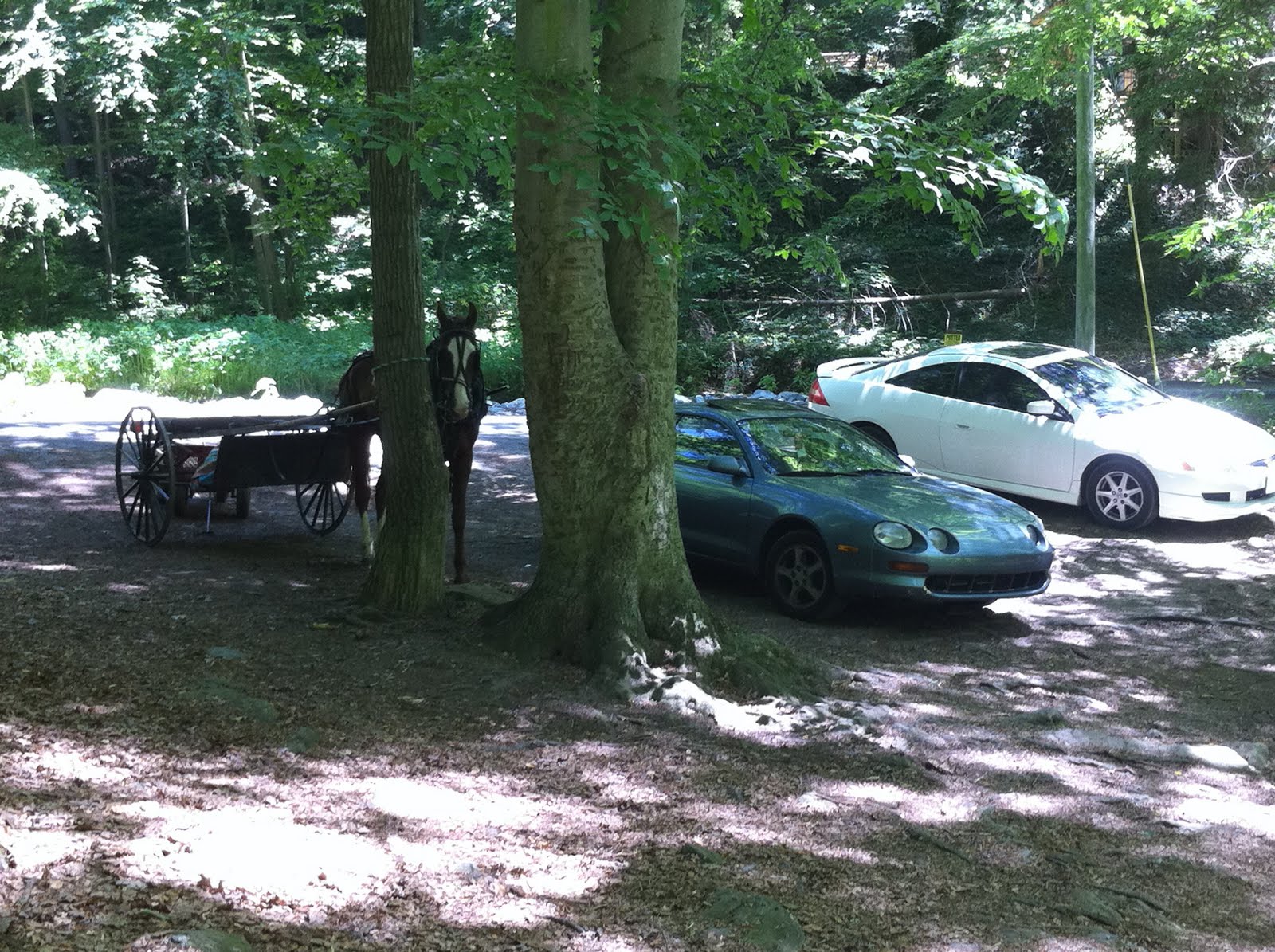
When the hike was over and we got back to the car I noticed an open horse & buggy parked near my car. I got excited and started taking photos like a typical tourist. We ate lunch across the street by the water only to be kicked out by a guy who told us we were trespassing on his property. Whoops, my bad! On the drive home while searching for gas I pulled into an ice cream shoppe to turn around and fill up my tank. I took it as a sign that we needed ice cream to celebrate the trip. Overall, the hike was amazing and I would totally go back. I might be falling for Lancaster county aka Farmville...
Facts
Location: Holtwood/Pequea, PA
Park: Tucquan Glen Nature Preserve
Trail: Tucquan Glen Loop = 2.1 miles
Time: 1-1.5 hrs
Elevation: 235 ft
Date: 6/2/11
Adventure
Originally I had planned to hike Kelly's Run on Thursday morning, a challenging trail recommended for "experienced outdoorsmen" (Mauricio you game?), but when I reviewed the schedule for the Philadelphia Trans Health Conference (PTHC) it no longer seemed applicable. I was looking to attend the PTHC on Friday and possibly Saturday, but the workshop held by GLSEN on Safe Schools was Thursday at 4pm and Kelly's Run is a 6 mile hike. I didn't want to chance missing the conference so I switched gears and pulled an easy two mile hike out of my "back pocket" list. All I knew about Tucquan Glen was that it had a waterfall and was a loop trail. I view trails as being challenging or scenic and so I had hoped to see something cool, but understood that it would be relatively easy. Kim suggested doing brunch that morning, but I roped her into the hike instead. I packed a cooler of water, T-fish & rel (oh, how I miss the UMASS days), some granola bars, chips and away we went to Lancaster county.
![]() |
| Entry to Tucquan Glen |
| New Friends |
| Getting Closer |
![]() |
| Parking! |
Monday, June 6, 2011
GEORGIA ON MY MIND
7TH HIKE: CUMBERLAND ISLAND
Facts
Location: St. Mary's, GA
Park: Cumberland Island National Seashore
Trail: Sea Camp & Dungeness
Time: 1.5 hours
Date: 5/22/11
Adventure
I woke up on Sunday morning at 7:30am with a little help from my cousin Carolyn. We had planned for a day of fishing on the boat in the St. Marys River and hiking on Cumberland Island. First, before hitting the water we went to a local bait and tackle shop to acquire minnows & shrimp as well as a fishing license for me. After getting the boat in the water we rode by all sorts of historical landmarks in addition to viewing Florida from the Georgia coast. We stopped several times to cast off some shrimp into the water. My first good tug and all I managed to reel in was a conch shell, the funny part is I actually thought there was a fish on my line. My cousin Will managed to catch two whitey's for the day and so did Carolyn, but I finished with a goose-egg. Midway through the day we decided to stop fishing and check out the trails and beaches on Cumberland Island.
First we walked along Sea Camp. The Island was absolutely gorgeous, the trees were large and covered in Spanish moss. The surroundings, although still green, were nothing like what I typically see in a day at Ridley Creek. All the plants, trees, and leaves were far more exotic. I saw lizards instead of squirrels. There were palm trees and I was drenched in sweat from the humidity. On the other side of the island (approx: .5mi) was the beach. I forgot to take a photo of the beach, mostly because I was so excited I ran into the ocean and played. Carolyn and Will were looking for shells and shark teeth. After our mini hike we sat on the island and had a picnic lunch of turkey & ham or PBJ sandwiches, doritios, chocolate chip cookies, and peanut butter crackers. We got back on the boat and headed to Dungeness. Anything more than a mile walk in the heat would have brutal and possibly resulting in heat stroke.
Dennis (Carolyn's husband), parked the boat by Dungeness where we saw tons of wild horses. I think the image of a wild horse next to a palm tree was probably the strangest for me, it just didn't make sense in my mind. We explored the ice house museum and passed a deranged tour where the guide talked about "decapating the Jesiuts and how that was the end of their visit to the island." We continued to see more wild horses and deer. We explored the ruins of the old Dungeness masion, the garden, pool house, and antique cars. After the hike we tried to fish one more time, but to no avail I went home empty handed, or without dinner I should say. When we got back to the house I sat in the back yard to fish for brim on the mini dock. While fishing my cousins and I drank the new Jack Daniels honey whiskey on the rocks, but had no luck with the fish (I finally caught one Monday morning before our second fishing trip). After a shower we spent the night relaxing on the porch/backyard, eating shrimp, drinking whiskey, and having good conversation. We talked of life, relationships, weddings, and delivering babies.
I have no doubt in my mind that I will return to Georgia. I loved everything about my vacation! Thanks again Carolyn :)
Facts
Location: St. Mary's, GA
Park: Cumberland Island National Seashore
Trail: Sea Camp & Dungeness
Time: 1.5 hours
Date: 5/22/11
Adventure
| St. Mary's River |
| Exotic Trail |
| Wild Horses & Palm Trees |
I have no doubt in my mind that I will return to Georgia. I loved everything about my vacation! Thanks again Carolyn :)
![]() |
| Hanging in a Tree on Sea Camp |
Wednesday, June 1, 2011
ON THE ROCKS, PLEASE!
6TH HIKE: HIGH ROCKS
Facts
Location: Pipersville, PA
Park: Ralph Stover State Park
Trail: Hike Rock Vista (? mi)
Elevation: 256 ft
Time: < 2 hours
Date: 5/13/11
Adventure
I was not sure if this hike could be squeezed into Friday, but naturally I had to try. The day began with breakie at my place, Kira came over for egg, pepper, & cheese omelettes, toast and strawberries. Kira gave me a chance to finally use the coffee maker I bought for company. Then around 1pm I scooped up Colette, we went to get a new ID for me and then we were off to the trails by 2pm. I had to be back by 6pm because I Friday nights I co-facilitate a youth group at Main Line Youth (as referenced in the previous blog). I was pushing it, by hiking a good hour away from home, but couldn't resist the thrill of adventure, especially since Colette was down to come out and play in the sunshine!
We arrived at Pipersville hungry from the journey there. I stopped at the local grill and ordered a blackened chicken panini. Colette waited in the restaurant while I went back into the car to change into shorts and a tank. We then got back on the road and lost on the way to the rocks. Finding Ralph Stover was easy, we then followed the signs stating that high rocks was five miles away. The tricky part came when we encountered an awkward turn and lost the signs. I ended up on the road below the high rocks instead of ascending upward and had to turn around. When we got to the trail we walked down to one of the viewpoints to check out the Tohickon Creek, from above. It was gorgeous!
Colette and I then walked down the trail looking for a good place to stop and eat lunch. While hiking a biker pointed out that he just 4.5 ft copperhead in the bush up ahead of us. I began pounding and stomping my feet along the trail in the hopes of scaring it. I must have been successful because we never came face to face with; however it would have made for an exciting story had we seen it. We turned around and went back to the top of the rocks to eat and enjoy the view. While eating lunch we watched two dudes assembling their rock climbing gear to drop down from the cliffs. After lunch we continued along the trail in the other direction and stopped at empty stream, filled with rocks that descended down to the creek. Colette and I began hoping from rock to rock all the way down to the bottom so we could play in the water. Truly I just wanted to jump on the rocks, stick my toes in the water, and take pictures from below. Colette was a trooper and enjoyed my wild trail selection (as I mentioned it was a dried up stream we walked down) with loose rocks, high walls, and moss. The way back up was far more grueling and I whipped out the inhaler to complete the rock climb. After briefly celebrating our victory back up to the top we got in the car and headed home. I made it not only on time to volunteer, but when I got there an additional facilitator had set up the chairs for group and purchased food for the meeting. Mega victory!
Facts
Location: Pipersville, PA
Park: Ralph Stover State Park
Trail: Hike Rock Vista (? mi)
Elevation: 256 ft
Time: < 2 hours
Date: 5/13/11
Adventure
I was not sure if this hike could be squeezed into Friday, but naturally I had to try. The day began with breakie at my place, Kira came over for egg, pepper, & cheese omelettes, toast and strawberries. Kira gave me a chance to finally use the coffee maker I bought for company. Then around 1pm I scooped up Colette, we went to get a new ID for me and then we were off to the trails by 2pm. I had to be back by 6pm because I Friday nights I co-facilitate a youth group at Main Line Youth (as referenced in the previous blog). I was pushing it, by hiking a good hour away from home, but couldn't resist the thrill of adventure, especially since Colette was down to come out and play in the sunshine!
![]() |
| View from the top |
![]() |
| Copperhead |
![]() |
| Colette Playing in the Creek |
Subscribe to:
Posts (Atom)